


By John Beech, Manawatu Tramping and Skiing Club
Gwavas Conservation Area covers 2,700 hectares of the Wakarara range in Central Hawkes Bay. It is one of four main stewardship blocks surrounding the Ruahine Forest Park. Ruahine East, Ruahine West and Awarua make up the other three, all adding to a total of 8,501 hectares. The Department of Conservation (DOC) manages the area for its soil and water conservation values, habitat and recreation values.
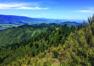
The Wakarara Range is predominantly steep broken hill country dissected by a number of small streams, with the largest being Poporangi and Poutaki. Like many other stewardship blocks Gwavas has been waiting for reclassification since the days of DOC’s inception. Most of the Wakarara Range was burnt or logged in the early settlers’ days and used for pastoral grazing. Since grazing ceased the range has reverted back to mainly kānuka/mānuka and scrub forests. Remnant pockets of red and black beech along with rimu, mataī and kahikatea are present in some of the gullies.
Awarua and parts of Ruahine West and East stewardship land were proposed for inclusion into the Ruahine Forest Park as outlined in DOC’s Hawkes Bay Conservation Management Strategy (CMS) published in 1994. None have been included as yet and Gwavas (the second largest block) was to be investigated for classification, but as yet no progress has been made.
In recent times a number of assessments have been carried out on small areas within or adjacent to the Gwavas block. One was carried out for the defunct Ruataniwha dam project that required the revocation of two small areas of the Ruahine Forest Park to be swapped for a larger block of Smedley Station land, the latter being on the boundary with the Gwavas Conservation block. Another survey was completed on a small portion of the southern end of the block. This was undertaken by Kessell’s ecology for the Central Hawkes Bay District Council (CHBDC) as part of their assessment and classification of Significant Natural Areas (SNA). The assessment concluded that the 29-hectare portion was significant and recommended the area be increased to 917 hectares. The criteria for significance included habitat or migratory pathways used by at-risk and threatened fauna, and areas greater than 20 hectares of indigenous vegetation. CHDBC has included the Gwavas Conservation Area in their schedule of SNA’s.
While carrying out the assessments for the Ruataniwha land swap, DOC identified the following species as being present – fish: long fin eel, torrent fish, redfin bullies and dwarf galaxias (although the Dutch Creek area that was surveyed is outside the Gwavas Conservation Area, it is not unreasonable to assume that some or all of these species could occur in the latter streams and wetlands). Fauna included long tailed bats, karearea and fernbird, but noting the proviso above. Other birds inhabiting the area include kererū, tūī, grey warbler and tomtit.
Recreationally, the area is not very popular because of its location and lack of tracks and huts. There is one track that leads to Poutaki Hut, the only DOC hut in the Wakarara range. Access is through Pan Pac Forests from the Wakarara Road-end, crossing the Makororo River and following the forestry roads to the end of Leatherwood Road. Thereafter, it is a steep climb on to the main ridge, then along the ridge and down the other side to the hut. Hunting is the most popular activity, with permits being given for weekend use only, due to access through a working forest. Pigs, deer and goats are the main introduced species and hares, possums, rats and stoats also inhabit the range.
Challenges for the area include the introduced mammals and the damage they cause, plus wilding pines that are slowly spreading in from the adjacent pine plantations.
This article is excerpted from the November 2019 edition of Backcountry Magazine titled “Forgotten Lands.” For more information or to subscribe to Backcountry, please visit https://www.fmc.org.nz/aboutbackcountry/.


