


This is just one of the stories in Simon’s Trips, a book honouring the life of NZ mountaineer, Simon Bell.
After his disappearance on Pikirakatahi/Mt Earnslaw in Jan 2015, his parents, Colin and Jeni Bell, compiled the book from Simon’s accounts and photos. Lorraine Johns, Rob Hawes, the late Steve Dowall and other friends also contributed stories of tramping or climbing trips they made with Simon.
Simon’s Trips was originally a gift to his family and friends but was later made available in return for a donation to the FMC Mountain and Forest Trust. These donations paid the majority of the costs of digitizing FMC’s publication ‘Safety in the Mountains’ (available here as the ‘Manual‘) and establishing the Wilderlife website. Simon’s estate contributed the balance.
We will be regularly re-publishing a number of stories from Simon’s Trips here on Wilderlife. If you would like the complete PDF, Simon’s Trips may be downloaded here, and a donation made here.
Simon’s account appeared in Vertigo (No. 760) and he gave a presentation to the Wellington Tramping & Mountaineering Club in September 2013. Here is an abridged version of his notes.
I’ve wanted to climb Sabre for ages. It is in the Darran Mountains which means the rock is quality! Also, I like the fact that, while the start is quite hard, it gets easier as you go up. Sabre is near Milford Sound. Other cool peaks around there are Mitre Peak, which is a great peak to climb I’ve heard! The highest peak is Tutoko. There are heaps of great peaks here. Also, many awesome rock climbs, ranging from single pitch sport routes and up.
Day 1 is is the walk in from Homer Hut to Gertrude Saddle, up to Barrier Knob, along towards Adelaide Saddle and down Gifford Gap. Then past a nice rock bivvy, which we didn’t have time to find, through a cliff band and to our bivvy site. Day 2 is the climb and return to bivvy site, with Day 3 being a nice walk out. It is pretty big country and wouldn’t be any fun in bad weather! Walking up to Gertrude Saddle is quite popular with tourists, although still difficult if the rock is wet. Once we got to Gertrude Saddle we met some tourists who had walked up and tented there for the night. It is a nice spot and there are some nice views on the way. The only problem is that there are helicopters flying past here quite often.
After Gertrude Saddle we went up and over Barrier Knob. Getting up to Barrier Knob involves snow travel. We did this trip in trail runners but we were prepared! You can follow a sidle track and avoid the snow. I know people who have done it, but it looked terrible to us! If you have flexible crampons, with some cunning you can attach them to trail runners. Just don’t try and front point. This really only works well on permanent snow in late summer. The snow is quite hard – there is no need for boots or gaiters! This made the trip better for us as we didn’t have to take boots at all – just trail runners for the approach and rock climbing shoes for the climb.

Mitre Peak from near Barrier Knob
This is a nice shot of Mitre Peak. I sent it to Lorraine just before she climbed it in order to try and psych her out! It didn’t work.

Vaughan walking along towards Adelaide Peak. Gifford Gap is on the right.
Some of the country is quite steep, but other parts are quite mellow, like in this shot.

Quite mellow: Lake Adelaide
However, to get down Gifford Gap requires some work. We are rapping it in this photo.

Absielling down Giffords Gap.
This terrain is quite big – even if you are going into this area for tramping, a rope still comes in handy. This section was bolted, although it is possible to downclimb this stuff when it is dry. When it is wet – don’t go near it.

Sabre Peak and the North Buttress.
This is Sabre and the North Buttress. It is a reasonable amount of work just getting to the base of the route. We had the time, so walked up to the base of the route on the day we walked in. Other people I know have stayed in a nice rock bivvy in the valley. The problem is, this then requires you to climb through cliff bands in the dark, and also risk spending a night away from your bivvy gear.
Getting over the snow was quite fun. Glad we did this in the day light! If the snow bridges collapsed it would be bad news – although they are pretty strong. The bluff systems were OK, but could be a very different story when it is wet or in the dark. After the cliffs, we got to a ‘flattish’ section and we ended up setting up camp here.

Vaughn at the flattish camp site.
Then we walked up to the base of the route. We spent ages trying to figure out the route. The photo below shows the approximate location of the first four pitches. We did pitch one and took a look at pitch two. Once we thought it was OK, we downclimbed pitch one (abseil wouldn’t work) and went back to base camp. We left our climbing ropes and gear at the base of the route.

Approximate route of the first 4 pitches.
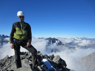
The cool thing about camping close to the route is you get to sleep in! We didn’t get up till 8am and we didn’t start climbing till 9:30am, once the sun was starting to hit the route. We did the climb with just one pack – meaning the leader doesn’t have to worry about weight on their back when climbing the harder sections. We left our trail runners at the base of the route. We were doing the climb and abseils and small snow section in rock shoes. We had a down jacket each and 4 L of water. We also drank heaps of water before we set off!

Vaughn tops up before the climb.
By the time we actually got moving, there was sun on the whole bluff, and things were nice and dry.

The crux pitch.
This is the crux of the climb, although it is a bit hard to see this. It is a long crack – maybe 25m or so. After this, it backs off quite a bit. Most pitches were 60m. It depended slightly, if you found a great belay ledge near 60m, that would do! We spent most of the climb, climbing in cloud!

Vaughan belays as Simon disappears into the clouds.
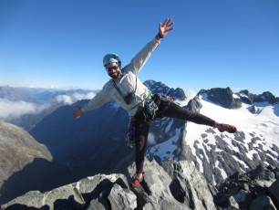
This is one my favourite photos of the trip! I was leading the third pitch and was lucky enough to lead the first four pitches. As soon as I went around the corner, I completely lost contact with the belayer and just climbed myself, up in the clouds! Sometimes it cleared and I managed to take a photo or two before the cloud came back in again. By now we felt pretty high up and exposed The steepness was backing off though. After simul climbing the last pitch (the 6th?) we took off the rope and started scrambling.

Simon’s Brocken Spectre.
This is a funny selection of things near the summit. The Brocken Spectre was cool! There were one or two rock bivvies near the top. People sometimes get caught out and have to spend a night at the top, normally without proper gear. We wouldn’t have had much fun, having only rock shoes and a down jacket each.

Rock bivvy near the top of Sabre Peak.
We drank the last of our water and ate the last of our food at the top, and got ready for the descent.
The descent was not too involved, but would have been very challenging in the dark. We were in bare feet – we were pretty sick of rock shoes by now.

Barefoot absiel.
It was maybe four or five 60m abseils (some were not full length) to the col. From the col we had about 30 minutes of daylight left. We still had two abseils to go. First was on a rock anchor and onto snow. This put us in the middle of a snow field.

Final views…
The snow was soft from afternoon sun but starting to go hard again. I downclimbed it with rock shoes and no ice axe but it was quite hard. Vaughan used the ice axe to make a snow bollard and abseiled off this which was the sensible thing to do! After this we had about a 10 minute walk in the dark to get to our trail runners. Then about 80 minutes to get back to the bivvy site. It would have taken 30 minutes in daylight but hey!


